 This area is very close to
the Salt Lake and Utah
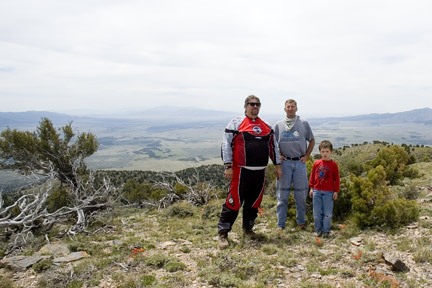
Valleys. It is a fun place to take someone to learn how to ride an
ATV and also a fun place to take the kids. There are flat trails,
some small hills and some very steep hills. There is also some nice
loop rides. From my house in South Jordan I can be there in less
than 1 hour (41 miles), which make this a great destination for
just the day. There are a lot of people on the weekends but
the area is so large with plenty of trails to disperse all the
people. The only bad about this area is that there are no facilities (no restroom
or picnic tables). Bring your own picnic lunch, table and awning
with the family and you can have a great family outing.
This area is very close to
the Salt Lake and Utah
Valleys. It is a fun place to take someone to learn how to ride an
ATV and also a fun place to take the kids. There are flat trails,
some small hills and some very steep hills. There is also some nice
loop rides. From my house in South Jordan I can be there in less
than 1 hour (41 miles), which make this a great destination for
just the day. There are a lot of people on the weekends but
the area is so large with plenty of trails to disperse all the
people. The only bad about this area is that there are no facilities (no restroom
or picnic tables). Bring your own picnic lunch, table and awning
with the family and you can have a great family outing.
Getting There:
 To get there from Salt lake Valley take Redwood
Road south, which is also Highway 68 past Camp Williams. At the
light (8570 N) take SR 73 west. From I-15 take the Lehi Exit and go
west on Main Street (Highway 73). You will go through Cedar Fort,
Fairfield and by Cedar Fort State Park. It is about 16 miles southwest
of Lehi. There is a larger parking area on the north side of the
road that can hold well over 100 trucks and trailers. Please remember
to watch your speeds in the parking area.
To get there from Salt lake Valley take Redwood
Road south, which is also Highway 68 past Camp Williams. At the
light (8570 N) take SR 73 west. From I-15 take the Lehi Exit and go
west on Main Street (Highway 73). You will go through Cedar Fort,
Fairfield and by Cedar Fort State Park. It is about 16 miles southwest
of Lehi. There is a larger parking area on the north side of the
road that can hold well over 100 trucks and trailers. Please remember
to watch your speeds in the parking area.
Watering Holes:
Food, Gas, and Groceries are at the gas station
in Cedar Fort or the intersection of Highway 73 and Redwood Road.
Camping:
 There is primitive camping anywhere you like
pretty much. Some of the best spots are: On the south side of the
road about 100 yards from the main parking lot just off Highway 73
up in the cedar trees against the hill. No trails behind there so
you won’t get a lot of dust or people driving in your camp. Another
couple of spots are the first and second roads west of the main
parking lot on the north side of the Highway about ¼ of a mile up in
the trees. This is over where people ride so you will have people
riding by your camp. If you want to let your kids ride around camp
during the day where you can watch them this is the place to camp.
Another good spot is west of the main parking lot on Highway 73 at
the turn off to Faust; there is a fork with 4 roads. The main
Highway 73, the Faust Road, the old rail road bed (dirt) and then a
dirt road that goes directly south. Take the dirt road that goes
directly south. There are a few primitive camping spots on the east
side of this road with less people riding though your camp
There is primitive camping anywhere you like
pretty much. Some of the best spots are: On the south side of the
road about 100 yards from the main parking lot just off Highway 73
up in the cedar trees against the hill. No trails behind there so
you won’t get a lot of dust or people driving in your camp. Another
couple of spots are the first and second roads west of the main
parking lot on the north side of the Highway about ¼ of a mile up in
the trees. This is over where people ride so you will have people
riding by your camp. If you want to let your kids ride around camp
during the day where you can watch them this is the place to camp.
Another good spot is west of the main parking lot on Highway 73 at
the turn off to Faust; there is a fork with 4 roads. The main
Highway 73, the Faust Road, the old rail road bed (dirt) and then a
dirt road that goes directly south. Take the dirt road that goes
directly south. There are a few primitive camping spots on the east
side of this road with less people riding though your camp
Riding
The riding area can be split up into north and
south of Highway 73. The land is a mix of BLM and private land. If
the land is private and posted to keep out please do keep out.
There are also plenty of trails already there so please don’t make
any new ones. Be considerate of others in the main parking lot and
campers, remember when you go by them your dust will remain there
for a while. There are a lot of old mines in this area. Don’t go
into them and stay safe.
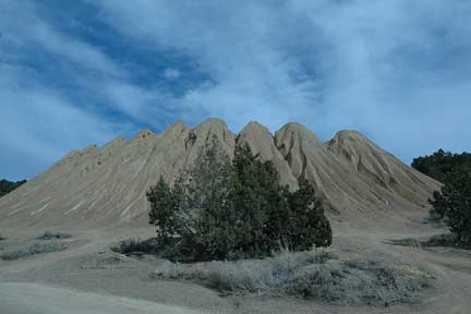
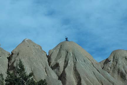
North Riding Area
This area has many trails that go everywhere.
There are flat trails with hills that you can climb. The more north
you get the steeper it gets. There is also a large hill directly
north of the parking lot that is fun to climb. There are so many
trails going every which way that it is hard to describe exactly
where to go. This area is just a lets go riding area picking
whatever trail and seeing where it takes you. For a loop trail go
west as much as you can and then start going north you will find some
mines that have had grills put over them, you can now start heading
east and you will end up east of the parking lot. Just take one of
the many trails south west to the parking area.
South Riding Area
 This area has a road that goes south at the
Faust Turnoff and follows the mountain range on the west side all
the way to Highway 36. There is another road on the east side of
the mountain that goes south from Cedar Fort State Park turn off,
all the way south to then town of Eureka. There are three roads that
connect these roads through passes. One at 7 mile pass, another at 10 mile pass
and the last at 12 mile pass. There are also many trails that go up
the many canyons. You could make a loop down to any one of the
passes and then back. There is also one canyon that goes up to
Dry lake.
This area has a road that goes south at the
Faust Turnoff and follows the mountain range on the west side all
the way to Highway 36. There is another road on the east side of
the mountain that goes south from Cedar Fort State Park turn off,
all the way south to then town of Eureka. There are three roads that
connect these roads through passes. One at 7 mile pass, another at 10 mile pass
and the last at 12 mile pass. There are also many trails that go up
the many canyons. You could make a loop down to any one of the
passes and then back. There is also one canyon that goes up to
Dry lake.
Winter Riding
Don’t
put that ATV away in the winter; this is a great place for riding in
the snow when there is less than a foot and half of snow. Anything over a
foot and a half and your ATV under carriage will float on
the snow and your wheels will never hit the dirt and you will be
stuck unless the trail is packed down.
GPS Waypoints
Dry Lake Trail Begin N40°00.592 W112°11.769 Altitude 7901 feet
Dry Lake N40°00.592 W112°11.769 Altitude 7901 feet